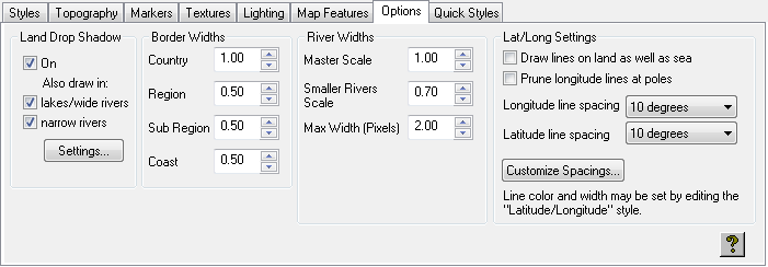
The Options panel allows you to control the land drop shadow, line widths, and the appearance of latitude and longitude lines.
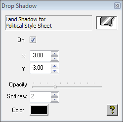
Land Drop Shadow: Allows you to specify whether land is displayed with a drop shadow, and whether a drop shadow is also displayed for lakes/wide rivers and/or narrow rivers. Click the Settings… button to define the shadow.
Border Widths: Allows you to specify the line widths for country, region, sub region, and coast outlines.
River Widths: Allows you to control the width of lines used to draw rivers that are not wide enough to be drawn as area shapes.
Master Scale: Affects the width of all rivers drawn as lines.
Smaller Rivers Scale: Affects the width of rivers which are classified as minor rivers.
Max Width (Pixels): Determines the maximum line width at which rivers are drawn. This is useful if you wish to prevent rivers being drawn as very thick lines as a map zooms in.
Lat/Long Settings: Allows you to control the appearance of the latitude and longitude lines, drawn in the Latitude/Longitude style.
To draw lines on both land and sea, select Draw lines on land as well as sea. If unchecked, the lines are drawn on the sea only.
To prevent longitude lines from drawing at the poles, where they are very close together and eventually meet, select Prune longitude lines at poles.
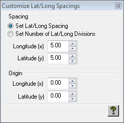
To alter the spacing of the longitude and latitude lines, choose an option from the appropriate line spacing pop-up menu, or choose Custom and click the Customize Spacings… button to specify the spacing or number of divisions and origin explicitly:
The color and width of the lines can be changed by choosing the Latitude/Longitude style on the Styles panel.