How to turn a map flight into a template — so a journalist can change where the camera goes, minutes before air, without opening the scene.

A GeoNavigator flight is a list of places and the movement between them. On its own that list lives in the scene, and changing it means opening Artist. ControlGeoNavigator is what lifts that list out into the template, so the destinations become something an operator fills in from Trio or Pilot like any other field.
The plugin describes itself as exposing a virtual list model for GeoNavigator camera pose fields. In plainer terms: the operator gets a list of hops. Each hop is one stop on the journey — where the camera goes, and optionally how it travels there.
The division of labour
GeoNavigator does the flying and holds the defaults. ControlGeoNavigator decides which parts of that an operator is allowed to change. You design the movement once; they supply the geography on the day.
What one hop contains
Every row in the operator's list is a camera pose plus the flight settings for getting to it. Only the fields you switch on appear — the rest keep the defaults you set on the GeoNavigator.
One hop
boundsWhere the camera ends up. Held as a geographic area rather than a point, so the hop frames a region rather than balancing on a coordinate. This is the only field the operator always needs.
bearingWhich way is up on arrival. Rotate to follow a coastline or a border.
pitchHow far the camera tilts from straight-down into perspective.
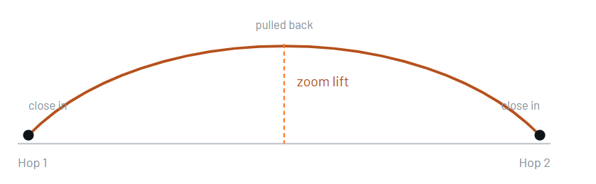
zoomLiftHow far the camera pulls back mid-flight before descending again — the arc of the journey.
durationHow long the flight to this hop takes.
timingModeWhether that duration is used as written, or worked out from the distance.
motionThe shape of the movement — steady, eased, or a true map flight.
flightDirectionWhich way round the globe to travel.
stopTypeWhether the flight halts here and waits for the next take, or pauses and carries on by itself.
pauseDurationHow long that automatic pause lasts.
userdataFree text carried on the hop. Useful for a caption, a lower-third cue, or the name of the place in your own words.
The shape of a flight
Two settings do most of the work in making a flight look deliberate rather than mechanical: how high the camera rises between stops, and how it accelerates.
Motion
Motion | Use it when |
|---|---|
| You want a constant, mechanical rate — usually because something else in the graphic is setting the rhythm. |
| Short hops. It eases in and out, which stops the move looking like it was cut from a longer one. |
| Long flights. It pulls back and pushes in automatically so the journey stays readable instead of skimming the ground at impossible speed. The default choice for anything continental. |
| The route itself is the story — a flight path, a shipping lane, an evacuation corridor. Follows the true shortest path over the globe. |
Direction, and why it has three options
Shortest picks the shorter way round and is right nearly always. East and West exist for flights near the date line, where the shortest path may cross the Pacific when your story is going the other way. If a flight between two Pacific locations swings the wrong way across the map, this is the setting that fixes it.
Stopping and pausing
A hop set to Stop halts the flight and waits — the operator takes the next stop when the presenter is ready. A hop set to Pause waits for the pause duration and then continues on its own. Stop is for live discussion; Pause is for a self-running sequence.
Choosing what the operator can change
This is the real design work. Each switch adds a column to the operator's list — and each column is one more thing that can be got wrong at ten to air.
Switch | Gives the operator |
|---|---|
| Control of the compass rotation at each stop. |
| Control of the camera tilt at each stop. |
| The height of the arc into each stop. |
| How long each flight takes. Often worth keeping — timings change with the running order. |
| The choice between an authored duration and one derived from distance. |
| The movement type per hop. |
| Which way round the globe. Worth exposing only for stories that go near the date line. |
| Whether each hop halts or pauses. Genuinely useful — it is the difference between a live-driven and a self-running sequence, and that changes per story. |
| How long an automatic pause lasts. |
| The free-text field on each hop. |
| The destination as an editable text value rather than a picked area. The one switch that starts off — see below. |
Bounds as text
Off by default, and that is usually right: an operator picking an area is harder to get wrong than one typing coordinates. Turn it on when the destinations arrive from another system — a newsroom feed, a results database, a script that writes the hop list — because then the value needs to be settable as text rather than chosen by hand.
A good template is a narrow one
Everything is exposed by default, which is convenient for testing and wrong for air. Start by switching most of them off. An operator with destinations, durations and stop types — three columns — works faster and makes fewer mistakes than one facing eleven. The movement style is a design decision you already made; it does not need re-deciding under pressure.
Building the template
Get the map working first
A GeoCanvas for the basemap and a GeoCamera on the same container. Add the camera yourself — creating the canvas does not create one. Fly around by hand and confirm the map looks right before any of the flight machinery goes in.
Add GeoNavigator and set the defaults
On the map container. Set motion, zoom lift, duration and timing mode to what a typical flight in this template should look like. These are the values every hop inherits, so spend time here — it is what stops the operator having to make design decisions.
Build a real flight and watch it
Capture two or three destinations with the camera, press Update Animation, and play it. You are judging the defaults, not the destinations. If a flight only looks right at one particular pair of locations, the defaults are wrong.
Add ControlGeoNavigator to the same container
It finds the GeoNavigator itself. Give it a field identifier and a description: the identifier is how the template addresses the list, the description is the wording the operator reads. Write the description as an instruction — “Places to fly to, in order” beats “GeoNavigator control”.
Switch off what they do not need
Go through the expose list and turn off everything the story does not require. This is the step that decides whether the template is pleasant or overwhelming.
Drive it from the client, not from Artist
Open it in Trio or Pilot as the operator will. Add a hop, reorder the list, delete one from the middle. Anything awkward here is worth fixing now, because on the day nobody will have time to work around it.
Prefetch, then save and reload
Run the tile prefetch so the first playback is not also the first tile fetch. Then save the scene, reload it, and check the controls come back with the same fields and values — that is the state the newsroom actually meets.
Things that catch people out
The animation does not rebuild itself. Changing hops or settings leaves the previously generated flight in place until Update Animation runs again. If a change seems to have done nothing, this is almost always why.
A ragged first run is tiles, not animation. If the flight looks perfect on the second playback and stuttery on the first, the map was still loading. Prefetch before air.
Expose flags are on by default. A template shipped without going through them gives the operator every field there is. Treat the defaults as a starting point for testing, not for delivery.
Exposing a field does not change the flight. It only decides who can edit it. A hop with nothing exposed still flies — using the GeoNavigator's defaults.
Expert mode hides, it does not disable. Fields marked expert stay functional; they just stop cluttering the everyday view.
A worked example
An election night template: the map opens on the whole country, flies to whichever state the desk wants to talk about, then drops into a single county.
Hop | Destination | Flight in | Ends |
|---|---|---|---|
1 | National | — | Stop |
2 | State — operator picks | Van Wijk, 3.0s, moderate lift | Stop |
3 | County — operator picks | Sine, 2.0s, little lift | Stop |
Exposed: destination, duration, stop type. Everything else — motion, lift, bearing, pitch, direction — stays with the designer. The desk can go anywhere in the country and re-cut the timing live, and cannot accidentally tilt the camera into the horizon while doing it.
Note the third hop uses Sine rather than Van Wijk: the state-to-county move is short, and Van Wijk's pull-back would put air between two places that are meant to feel adjacent.