Viz World Plug-ins Guide
Version 17.0 | Published January 10, 2019 ©
3D Roads
![]()
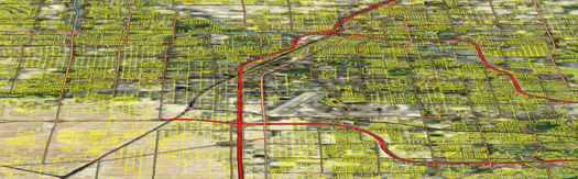
The 3D Roads plug-in overlays road data onto a map. This plug-in is mainly used with a 3D Line Shader plug-in.
The plug-in has three different editor views:
-
Data: Defines what type of roads are drawn by the selected 3D Roads object. Select one or more types of roads to be displayed, using the plug-in graphic properties.
-
Width: Defines the width of the roads drawn by the plug-in.
-
Outline: Defines the objects outline properties and behavior.
-
Advanced: Defines extra settings on how to handle texture mapping and low angle compensation when drawing streets.
Note: This plug-in is located in: Built Ins -> Geometry plug-ins -> Maps
3D Roads Properties
Data
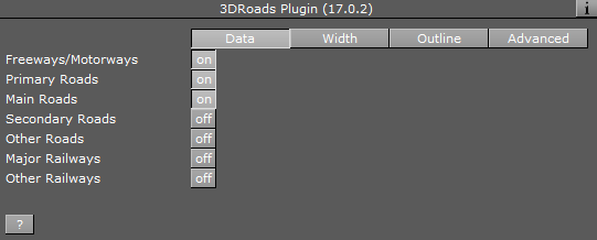
-
Freeways/Motorways, Primary, Main, Secondary and Other Roads: Draws roads rated according to the selection in the loaded roads data when enabled (On).
-
Major and Other Railways: Draws railways rated according to the selection in the loaded railways data when enabled (On).
Width
Selects how the road width is calculated.
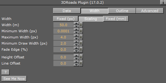
-
Fixed (Pixels): When set to Fixed the road maintains a fixed width during camera zoom movements. Available options are Width (pixels) and Fade Edge (%).
-
Width (Pixels): Sets the width of the roads in number of pixels.
-
Fade Edge (%): Sets the percentage of softness applied to the road edges.
-
Height Offset: Offsets the borders from the map (on the fly).
-
-
Scaling: When set to Scaling the road width varies according to the camera zoom movements. When selected, the following parameters are available:
-
Width (Meters): Sets the physical road width (in Meters). This value is translated into drawn pixels according to the camera zoom position and the size of the map.
-
Minimum Width (Pixels): Sets the minimum size of the roads drawn. If the calculated road size in pixels is lower than the minimum width, the road is not drawn.
-
Maximum Width (Pixels): Sets the maximum size of the roads drawn. If the calculated road size in pixels is higher than the maximum width, the road width is set to the maximum width.
-
Minimum Draw Width (Pixels): Sets the minimum size of the roads drawn. When zooming into an area, this is the point where the roads begin to fade in and are drawn over the map.
-
Fade Edge (%): Sets the percentage of softness applied to the road edges.
-
See Me Now: Calculates (when width is set to scaling) the width needed for the line to be visible at a given distance.
-
-
Fixed (mm): When set to Fixed (mm) the road maintains a fixed width during camera zoom movements. When selected, the Width (mm) and Fade Edge (%) parameters are available.
Outline
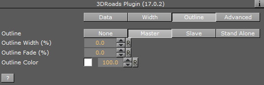
-
Outline: Selects one of the options for adding outline to the roads. Available options are None, Master, Slave and Stand Alone.
-
None: Does not add an outline to the roads drawn by the plug-in.
-
Master: Controls other 3D Roads plug-ins which are in slave mode. The same outline attributes are applied to roads drawn by the master plug-in and by all its slave plug-ins. When selected, additional parameters are Outline Width (%), Outline Fade (%) and Outline Color.
Note: The master setting ONLY controls other plug-ins, it does not draw any outlines itself. If there are no slave plug-ins, then no outlines are visible.
-
Slave: Draws the outline according to the defined outline in the master plug-in above it in the scene hierarchy. All other parameters are disabled, displaying the master’s values.
-
Stand Alone: Defines the outline parameters for the roads drawn by this 3D Roads plug-in only. When selected, available additional parameters are Outline Width (%), Outline Fade (%) and Outline Color.
-
-
Outline Width (%): Sets the width of the outline, as a percentage of the road width, where 0% is the road width.
-
Outline Fade (%): Sets the percentage of softness applied to the outline edges.
-
Outline Color: Sets the color of the outline and the alpha value of the outline.
Note: The hierarchy structure is important when using the master/slave outline configuration. The master plug-in should always reside as the first container in the group of 3D Roads containers. An Expert plug-in should be added to the map (above the 3D Roads containers) and Z-Buffer Draw should be set to Off.
Note: Road data should be loaded (using the CWMClient plug-in) before working on roads design.
Advanced
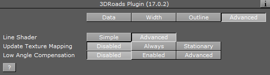
-
Line Shader: Line shader has two variants. The first is Simple with fewer options (and better performance), while the second is more Advanced and allows for more options (but at the cost of performance).
-
Update Texture Mapping: Defines when to update the mapping of textures applied in the container:
-
Disabled: Does not ever update the mapping of the texture.
-
Always: Updates the mapping of the texture while animating.
-
Stationary: Updates the mapping of the texture only when the scene is stationary or not an animation.
-
-
Low Angle Compensation: Used when creating graphics that have a low angle point of view or tilt in order to remove aliasing on lines far away from the camera.
-
Wireframe: Displays the roads as wireframe.
-
Debug: Enables debug messages in the console.
-
Min Angle: If the angle between the camera and the ground below the line is lower than Min Angle, then line width and transparency are not changed.
-
Max Angle: If the angle between the camera and the ground below the line is higher than Max Angle, then the line width is increased by the Width Factor and the transparency is scaled by the Alpha Factor. If the angle is between Min Angle and Max Angle then the width and transparency are interpolated.
-
Outline Angle Offset: For outline width, apply an offset to the angle calculation in order to make the outlines affected at higher angles than the lines themselves.
-
Width Factor (%): Determines the factor for modifying line width when applicable. Percentage value for the width of the line far away from the camera. For example, 400% thicker than when it is close to the camera.
-
Alpha Factor (%): Determines the factor for modifying line alpha when applicable. Percentage value for the alpha of the line far away from the camera.
-