Viz World Plug-ins Guide
Version 17.0 | Published January 10, 2019 ©
MapScale
![]()
The MapScale plug-in displays the scale factor of the map.
Note: This plug-in is located in: Built Ins -> Geometry plug-ins -> Maps
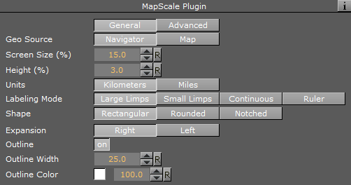
MapScale Properties
General
-
Geo Source: Bases the scale or zoom factor data on the navigator plug-in, when set to Navigator. When set to Map, the values are based on the defined Map container.
-
Screen Size (%): Defines the screen geometry size, measured as percentage of the screen on the X axis.
-
Height (%): Defines the height geometry, measured as percentage of the screen on the Y axis.
-
Units: Displays units in Kilometers or Miles.
-
Labeling Mode: The Large/Small Limps options try to find the closest round number in the visible range. While gradually zooming in or out, the rectangle containing the map scale is scaled according to a visible number. When the range limit is reached, the number changes and the rectangle jumps to a new range. This may result in an unpleasant visual effect, so the Continuous mode is used where the rectangle showing the scale remains unchanged and the numbers showing the range change continuously without jumps.
-
Large Limps: Changes the text display when the scale factor changes significantly (e.g. 1000KM, and next limp 500KM).
-
Small Limps: Changes the text display when the scale factor is a smaller change (e.g. 1000KM, and next limp 900KM).
-
Continuous: Provides an exact number of the coverage area of the geometry.
-
Ruler: Combines Continuous and Limps modes. While the total width of the rectangle remains unchanged, notches are added showing the rounded range.
-
-
Shape: Determines the shape of the edges: Rectangular edges, Rounded Edges or Notched left and right. When using Notched, an additional parameter is visible for the direction for the notches (Up/Down/Both and the height and width of each notch).
-
Expansion:
-
Outline: Toggles the outline of the geometry.
-
Outline Width: Defines the width of the outline when outline is enabled (On).
-
Outline Color: Defines the color of the outline when outline is enabled (On).
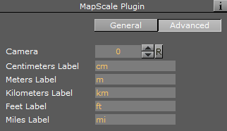
Advanced
-
Camera: Determines the camera for placing the geometry.
-
Centimeter/Meter/Kilometers/Feet/Miles Label: Defines the suffix for each unit.