Viz World Plug-ins Guide
Version 17.0 | Published January 10, 2019 ©
GeoImage
![]()
The GeoImage plug-in enables geographic referencing options. The plug-in is used as a base object with maps. GeoImage is short for Geographical Reference Image.
The plug-in has three views:
Note: This plug-in is located in: Built Ins -> Geometry plug-ins -> Maps
GeoImage Properties
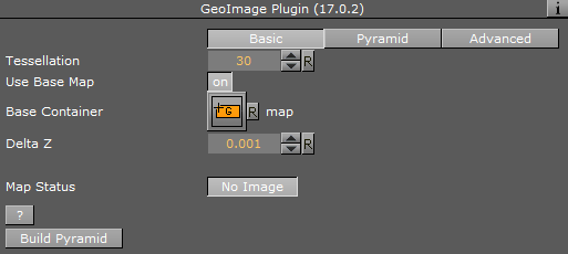
Basic
-
Use Base Map: Defines the geographical referencing of the GeoImage. If Use Base Map is enabled (On), the GeoImage moves to its geographic location on the base map and resizes accordingly.
-
Map Size: Sets the size of the GeoImage geometry if Use Base Map is set to Off.
-
Tessellation: Changes the number of triangles of the rendered filecard to increase the visual quality.
Note: The number of triangles affect the performance of the system.
-
Base Container: Uses the first geo-referenced map above the GeoImage container in the hierarchy as the base map if empty. To use a specific map as the base map, drag a map container to the Base Container place holder.
-
Delta Z: Sets a Z offset for the GeoImage geometry.
-
Map Status: Displays the status of the imagery and whether the imagery contains geo-referencing.
-
Apply Fade Plugin: Applies a Fade Texture plug-in to the container when clicked.
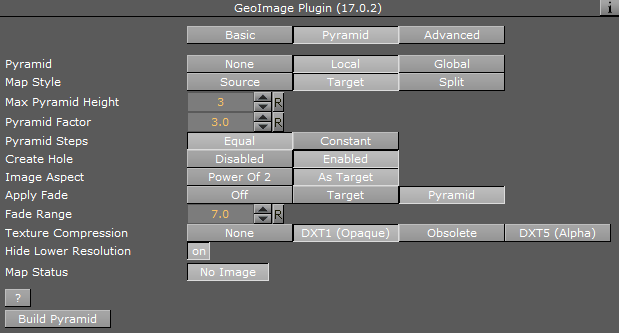
Pyramid
-
Pyramid: Uses local parameters when to set to None or Local. When set to Global, it uses the parameters as defined in the Hops Manager.
-
Map Style: Defines the map style to be used for the pyramid maps:
-
Source: Uses the top CWMClient container (Map Tiler) style selection when creating the pyramid maps.
-
Target: Uses the hop CWMClient style selection when creating the pyramid maps.
-
Split: Splits the pyramid layers style, based on image latitude and longitude size. If the image size is smaller then the threshold the target style is used, if larger then the source style is used. Additionally, it is possible to turn on the color correction option in Pyramid Control which color corrects the target image to match the source images. Set the Satellite Threshold (deg).
-
-
Max Pyramid Height: Defines the maximum number of maps that are created in the pyramid. The optimal number of pyramid maps is calculated by the Map Pyramid plug-in. If the optimal number exceeds the Max Pyramid Height value, then the plug-in generates the maximum number defined.
-
Pyramid Factor: Calculates the number of maps required defining the size factor between the maps of the pyramid.
-
Pyramid Steps: Defines how the map coverage area grows from pyramid to pyramid:
-
Equal: The size factor is based on map pyramid height, pyramid factor and the resolution difference between the base map and the final map. The actual number might be different than the pyramid factor. The number of levels might also be smaller than the max pyramid height
-
Constant: Uses the value of the pyramid factor as is, with the value of max pyramid height.
-
-
Create Hole: Creates a hole on each pyramid tile.
-
Image Aspect: Calculates the closest power of two size, based on the selected image size of the CWMClient plug-in texture size. Target uses exactly the same size as the CWMClient plug-in texture size.
Note: It is recommended to use this setting to improve performance.
-
Apply Fade: Defines whether the maps used in the pyramid uses soft edges. Available options are Off, Target and Pyramid.
-
Off: Does not use soft edges. The transition between the maps is visible (the maps have sharp edges).
-
Target: Sets the last map (target) to have soft edges only.
-
Pyramid: Sets all maps in the pyramid to have soft edges.
-
-
Fade Range: Sets the fade level (the area of the image that the fade is applied to) when the Apply Fade parameter is used.
-
Texture Compression: Selects one of the required compression modes for the images.
-
Hide Lower Resolution: Defines whether the map created by the CWMClient plug-in, located on the Map Pyramid container, is turned off when the texture resolution of that map is lower than the Globe or GeoImage map tiles resolution. If it is enabled (On), the maps with lower resolution is turned off automatically by the Map Pyramid plug-in. If it is disabled (Off), the Map Pyramid does not turn off the low resolution maps.
-
Map Status: Determines the status of the map.
Advanced
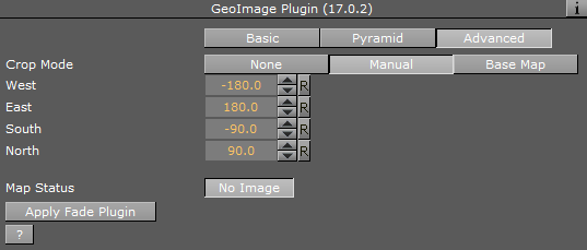
When the Use Base Map option on the Basic tab is turned on, the Advanced tab displays parameters for cropping the imagery applied on this container.
-
Crop Mode: Defines whether the GeoImage is cropped:
-
None: Does not crop the map.
-
Manual: Sets the crop values using manual values for the map: West and East set the Longitude value for the western and eastern edge of the GeoImage map. North and South and set the Latitude value for the northern and southern edge of the GeoImage map.
-
Base Map: Crops the GeoImage according to the base map, that is, if the GeoImage exceeds the base map edges, it is cropped accordingly.
-