
Viz World Classic User Guide
Version 23.0 | Published December 12, 2023 ©
Map Features Panel
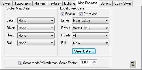
The Map Features panel allows you to define the map and street data to be included in the map layer, and the scaling of road and rail features.
You can override these for a particular map layer using the Map Features dialog box; see the Setting Map Features section.
Global Map Data
Allows you to specify which lakes, rivers, roads, and rail features are displayed by choosing the appropriate option from the corresponding drop-down menu.
Local Street Data
Allows you to specify which lakes, rivers, roads, and rail features are displayed in street data by choosing the appropriate options from the corresponding drop-down menu.
The Enable option allows you to specify whether or not street data is displayed in the map layer.
The Street Data... button displays the Street Data Directory dialog box, and is equivalent to choosing Street Data… from the Import menu.
For more information about working with street data see the Working with Street Maps section.
Scale Roads/Rail with Map
Determines how roads and railways are scaled as the map is scaled.
The Scale Factor setting is used to scale all line features, such as road, rail, and rivers. You can adjust the value to achieve particular effects; for example, reduce it below 1.00 to make all line features thinner.